|
|
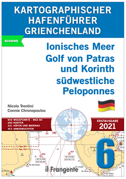
Ionisches Meer, Golf von Patras und Golf von Korinth südwestliche Peloponnes
KARTOGRAPHISCHER HAFENFÜHRER 6
N. Trentini e C. Chronopoulou
Dieser Hafenführer umfasst die Inseln des Ionischen Meeres mit den Golfen von Patras und Korinth sowie den südwestlichen Teil der Peloponnes.
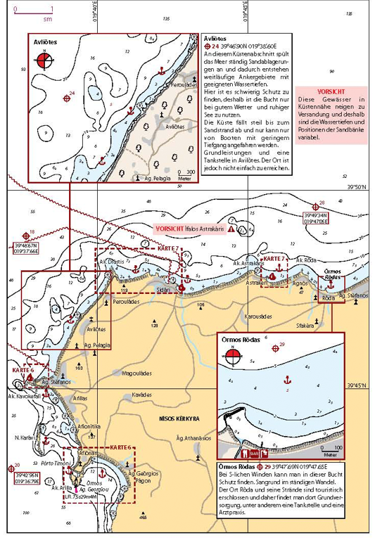
Sein wichtigster Bestandteil sind die 200 Karten, auf denen Häfen, Marinas und Ankerplätze für jede Navigationszone detailliert dargestellt sind..
Die Einleitung beinhaltet die hauptsächlichen Entfernungen und Routen, sowie eine Auflistung von Papierseekarten und elektronischen Seekarten.
Das ganze Gebiet ist in acht Zonen unterteilt, für die jeweils zwei Info-tabellen vorgesehen sind: Die Erste führt die wichtigsten Häfen und Marinas mit ihren Service-Einrichtungen auf (Wasserund Stromsäulen, Kraftstoff, Reparaturwerkstätten, usw.); die Zweite enthält Ankerbuchten mit den wichtigsten Eigenschaften (Schutz, Wassertiefe, Verpflegung an Land, usw.). Ein kurzer Blick genügt, um das geeignete Ziel auswählen zu können je nach Wetterlage und Dimension des Bootes.
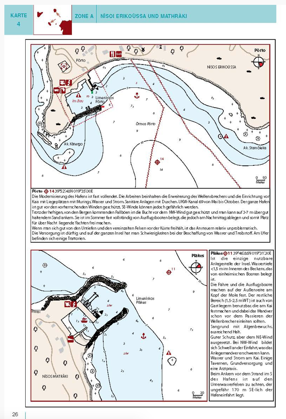
Die 221 Hafen- und 413 Ankerbuchtpläne sind umfassend und dank einer großen Auswahl an Piktogrammen äußerst benutzerfreundlich. Kurze Texte ergänzen die für eine sichere Navigation unentbehrlichen Informationen. Mittels einer einfachen aber hilfreichen Windrose hat man alle vorherrschenden Windrichtungen im Blickpunkt.
|
|
|
AEGEAN SEA, Eastern Peloponnese Saronic Gulf Cyclades
PILOT BOOK 7
N. Trentini e C. Chronopoulou
A pilot is a fundamental companion to nautical charts and contains all the information that a yachtsman needs, but cannot be included on the charts themselves.
This guide and its 225 user-friendly charts show all of the available harbours, marinas and anchorages within this navigation area.
The introduction includes a table with distances and the main routes, a list of printed and digital charts, as well as local weather information.
The entire area is divided into eight macro-zones. Each one has its own quick guide that includes waypoints, harbour and marina facilities, plus the main features of local anchorages (e.g. nature of the seabed, shelter, facilities ashore). At a glance, you will be able to decide where to head based on your yacht and the weather.
Each chart has an icon that shows the harbour or bay position within the navigation area. This way you will always know exactly where you are.
This guide also comprises 214 plans for harbours and marinas, and 544 plans for bays and anchorages, each with a wealth of practical symbols and overviews providing complementary information so that you can sail with peace of mind. A handy wind-rose icon gives wind direction and exposure for each plan.
The pilot numbers:
902 WAYPOINT IN WGS 84
225 CHARTS
214 HARBOURS AND MARINAS
544 BAYS AND ANCHORAGES
|